Contents
- Corporate profile
- Key statistics 2009
- Key features 2009
- Operations at a glance
- FY09 – milestones
- Harmony strategy
- Chairman’s letter
- Chief executive officer’s review
- Review of operations
- Exploration overview
- Mineral resources and ore reserves
- South Africa
- Free State
- Elandsrand
- Doornkop
- Evander
- Kalgold
- Papua New Guinea
- South Africa
- Board of directors
- Executive management
- Corporate governance
- Directors’ report
- Report of the independent auditors (PDF - 37KB)
- Group annual financial statements (PDF - 312KB)
- Company annual financial statements (PDF - 123KB)
- Statement of subsidiary companies (PDF - 48KB)
- Investor relations
- Glossary of terms
- Administrative information
Elandsrand
Geology: The structure of the orebody on the Far West Rand is dominated by a series of east-trending normal faults with throws of up to 40m, as well as a series of north-north-east striking normal faults with generally smaller displacements in the north-west. Faulting is generally less prevalent than in other Witwatersrand Basin goldfields. The primary reefs exploited are the Ventersdorp Contact Reef (VCR) and the Carbon Leader, separated by 900 to 1 300 metres, increasing from east to west. Secondary targets are the Middelvlei Reef (50 to 75 metres above the Carbon Leader) and the Mondeor Conglomerate Reef Zone, which sub-crops beneath the VCR at Deelkraal and on the western side of Elandsrand.
![Location of operations: Harmony Elandsrand [map]](i/elandsrand_map.gif)
![Elandsrand – Section through main shaft and sub-shaft looking east (Not to scale) [map]](i/elandsrand_section.gif)
![Elandsrand shaft – Ventersdorp Contact Reef (VCR) [map]](i/elandsrand_shaft.gif)
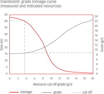
Mineral resources
| Measured | Indicated | Inferred | Total | |||||||||||||
|---|---|---|---|---|---|---|---|---|---|---|---|---|---|---|---|---|
| Operations | Tonnes (Mt) | g/t | Gold (000kg) | Gold (000oz) | Tonnes (Mt) | g/t | Gold (000kg) | Gold (000oz) | Tonnes (Mt) | g/t | Gold (000kg) | Gold (000oz) | Tonnes (Mt) | g/t | Gold (000kg) | Gold (000oz) |
| Underground | ||||||||||||||||
| Elandsrand | 11.6 | 8.87 | 103 | 3 313 | 28.2 | 8.63 | 243 | 7 812 | 1.4 | 9.28 | 13 | 431 | 41.2 | 8.72 | 359 | 11 556 |
| GRAND TOTAL | 11.6 | 8.87 | 103 | 3 313 | 28.2 | 8.63 | 243 | 7 812 | 1.4 | 9.28 | 13 | 431 | 41.2 | 8.72 | 359 | 11 556 |
Modifying factors
| Operations | MCF (%) | SW (cm) | MW (cm) | PRF (%) |
| Elandsrand | 87 | 129 | 160 | 96 |
- MCF = Mine call factor
- MW = Milling width
- SW = Stoping width
- PRF = Plant recovery factor
Ore reserves
| Proven | Probable | Total | ||||||||||
|---|---|---|---|---|---|---|---|---|---|---|---|---|
| Operations | Tonnes (Mt) | Grade g/t | Gold (000kg) | Gold (000oz) | Tonnes (Mt) | Grade g/t | Gold (000kg) | Gold (000oz) | Tonnes (Mt) | Grade g/t | Gold (000kg) | Gold (000oz) |
| Underground | ||||||||||||
| Elandsrand | 11.5 | 6.50 | 74 | 2 395 | 26.2 | 6.11 | 160 | 5 146 | 37.7 | 6.23 | 234 | 7 541 |
| GRAND TOTAL | 11.5 | 6.50 | 74 | 2 395 | 26.2 | 6.11 | 160 | 5 146 | 37.7 | 6.23 | 234 | 7 541 |
Harmony Annual Report 2009