Contents
- Corporate profile
- Key statistics 2009
- Key features 2009
- Operations at a glance
- FY09 – milestones
- Harmony strategy
- Chairman’s letter
- Chief executive officer’s review
- Review of operations
- Exploration overview
- Mineral resources and ore reserves
- Board of directors
- Executive management
- Corporate governance
- Directors’ report
- Report of the independent auditors (PDF - 37KB)
- Group annual financial statements (PDF - 312KB)
- Company annual financial statements (PDF - 123KB)
- Statement of subsidiary companies (PDF - 48KB)
- Investor relations
- Glossary of terms
- Administrative information
Exploration overview
Harmony is continuing to expand its exploration presence and effort. In FY09, the total spent on exploration and projects in South Africa, Australia and Papua New Guinea (PNG) was R289 million (US$32 million). The Harmony group exploration budget is set at R270 million (US$35 million) for FY10.
Our exploration strategy is focussed on key prospective geological terrains with the potential for large, long-life gold ore bodies. Harmony’s approach is to develop and maintain a balanced pipeline of projects across all stages of the exploration process – i.e. from project generation, advanced projects, resource definition and projects moving into prefeasibility. This includes:
- Brownfields exploration work to maximise value from existing infrastructure around current operations.
- Greenfields exploration in remote areas of PNG including Morobe Coast, Mt Hagen and Amanab.
- Maintaining flexibility in accessing quality projects through joint venture partnerships, acquisition, or by developing these in-house.
- Application of filter criteria based on project- and country-related risk and the ability to meet minimum size requirements (potential size/production profile).
In PNG, significant milestones and successes from the FY09 exploration programme included:
- Initiation of the Morobe Mining Joint Venture (Harmony 50%, Newcrest 50%) for exploration on the Morobe tenement holding encompassing the Wafi-Golpu and Hidden Valley projects
- Completion of initial resource drilling at the Nambonga North Prospect at Wafi-Golpu and the declaration of a new, inferred porphyry copper-gold resource comprising 1.0 million ounces of gold and 80,000 tonnes of copper, 50% attributable to Harmony
- Development of major porphyry and epithermal targets at Miapilli, Kesiago and Pekumbe, located along strike from Golpu on the Wafi Transfer Structure as part of the ongoing grassroots exploration programme
- Expansion of Harmony’s PNG exploration portfolio into the Sandaun and Western Highlands provinces as a result of project generation activities.
In South Africa, highlights from the FY09 exploration programme included:
- Good progress at Evander South in Mpumalanga as the drilling programme here nears completion by year-end and suggests the potential for extension into the Poplar area.
- Start of exploration drilling at Joel North to upgrade resources and extend mine life.
Papua New Guinea exploration projects
PNG contains one of the world’s most prospective geological terranes for porphyry copper-gold and epithermal gold mineralisation. The New Guinea mobile belt spans the core of the Irian Jaya – PNG Mainland and is host to major deposits which include Grasberg-Ertzberg (copper-gold), Porgera (gold), OK Tedi (copper-gold), Hidden Valley (goldsilver), Misima (gold), Frieda River (copper-gold), and Wafi-Golpu (gold and copper-gold). The mobile belt is demonstrably underexplored, and represents the key prospective geological terrane central to Harmony’s exploration strategy.
Although the majority of exploration expenditure in FY09 was in Morobe Province on Morobe Mining Joint Venture tenements, work during the year also included developing new projects in this highly prospective region. Two new projects, Amanab in the Sandaun Province, and Mt Hagen in the Western Highlands Province, were generated and consolidated by Harmony after year-end and will form a significant portion of Harmony’s exploration effort in FY10.
These 100% Harmony-owned leases complement the exploration activities undertaken by the 50% Harmony-owned Morobe Mining Joint Ventures and underscore Harmony’s commitment and belief in the developing minerals industry in PNG.
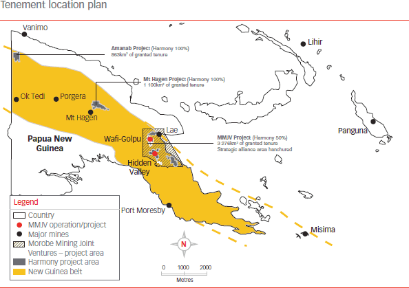
Morobe Mining Joint Ventures Project (Harmony 50%)
The land holding encompassing the Wafi-Golpu and Hidden Valley projects has now become part of the Morobe Mining Joint Ventures strategic alliance area, where both Harmony and Newcrest have agreed to operate as joint venture partners. This tenement package comprises 3 276 square kilometres of tenure and is centred on the Morobe goldfields.
The Morobe district is a growing gold province. The total known gold endowment is more than 19 million ounces of gold. In addition, the 4.1 billion pounds of copper, 47 million pounds of molybdenum, and 84 million ounces of silver add significant value to the known resources in the district.
Since Harmony began its exploration activities here in 2002, the resource inventory for Morobe Mining Joint Ventures has grown from 7.3 million ounces to 15.6 million ounces of gold. In FY09, exploration was successful in converting the Nambonga North prospect into a resource of over 1.0 million ounces of gold and 86 000 tonnes of copper, of which 50% is attributable to Harmony.
Exploration was undertaken on 19 separate prospects during the year. Initiatives to accelerate prospect turnover and development have been successful. Exploration statistics for FY09 include:
- 39 385 metres of diamond drilling
- 12 059 surface samples (soils, rock chips, trenches)
- Over 12 000 line kilometres of detailed airborne magnetics
- Geophysical IP-EM surveys at Biamena and Kesiago Prospects
The drilling component represents a threefold increase on FY08.
This momentum is set to continue in FY10, backed by the combined skill-sets of both Harmony and Newcrest. A budget of $AUD 22.8 million for the Morobe exploration joint venture – 42% for greenfields, 58% for brownfields activities – has been approved by the venture partners.
Wafi-Golpu brownfields exploration
Brownfield exploration surrounding the Wafi-Golpu deposits in FY09 focused on defining additional mineral resources to impact development of the project. Compilation and interpretation of the historical Wafi-Golpu datasets were undertaken to create a new, integrated 3D geological model. This work highlighted the north and north-eastern margins of the central diatreme intrusive as being underexplored, and prioritised the area for follow-up work in FY10.
Exploration during the first half of FY09 was directed at scoping and delineating the Nambonga North porphyry resource. Subsequent reconnaissance drilling along strike to the north-east of the Golpu resource on the Wafi Transfer identified significant anomalism at the Miapilli Prospect.
Wafi brownfields project
Wafi-Golpu Project
The Wafi gold and Golpu copper-gold project footprint was expanded during FY09 to include the Nambonga porphyry copper-gold resource. The project area now contains 11.1 million ounces of gold, 47 million pounds of molybdenum and 4.1 billion pounds of copper.
Concept studies to investigate development alternatives and unlock the value of this major resource remain a priority for FY10. A new consolidated resource model incorporating Nambonga and several previously un-modelled zones of gold and silver mineralisation is currently being constructed, and will be contemplated as part of this process.
Drilling continues to target additional surface resources and expansion of the known deposits along strike and at depth.
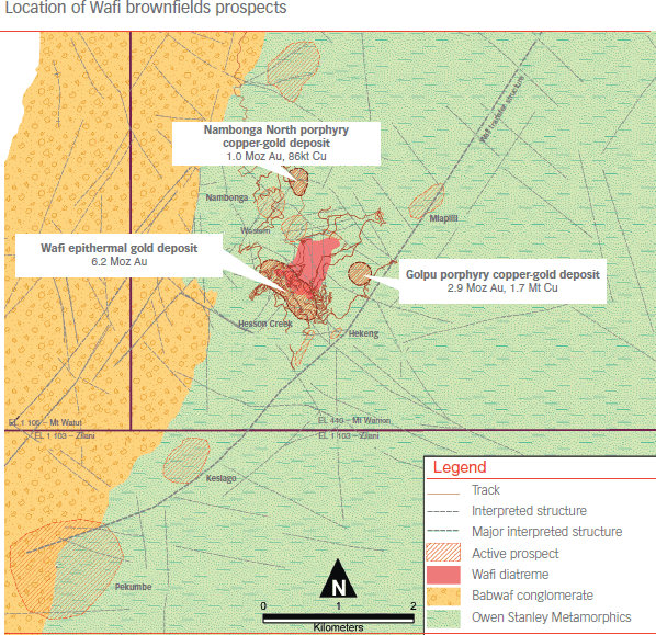
Geology and prospect location plan showing Wafi brownfields prospects within EL440 and regional greenfields exploration prospect locations along the Wafi Transfer structure.
Nambonga North
The Nambonga North prospect, which lies approximately 2 kilometres north-west of Golpu, was progressed during the year from an advanced prospect into an inferred copper-gold porphyry resource of 39.8Mt @ 0.8g/t Au and 0.2% Cu for 1.0M oz Au and 86Kt Cu. (50% attributable to Harmony). Importantly, this recent discovery represents the second mineralised copper-gold porphyry in the region that does not outcrop at surface.
Miapilli
The Miapilli prospect is located north-east along strike of the Wafi-Golpu porphyry copper-gold deposit on the Wafi Transfer structure and was recognised based on a circular magnetic anomaly, interpreted to represent an alteration halo associated with intrusion of a porphyry body at depth.
Three initial drillholes for a total of 2 060m were completed and magnetic bodies modelled from the regional magnetics. While the two northern holes drilled failed to intersect any indications of mineralisation, the southernmost hole, WR307, intersected altered and mineralised metamorphic host rocks, adjacent to an andesitic intrusive. Significant anomalous mineralisation was encountered in this hole, including:
- 35m @ 0.4g/t Au and 0.1% Cu from 224m
- 16m @ 0.4g/t Au from 270m
Follow up drilling of this initial result identified a large stockwork and alteration ystem, with anomalous gold and copper mineralisation over approximately 350mdh. Hole WR315 returned a best intercept of:
- 52m @ 1.0g/t Au and 0.2% Cu from 409m
This intercept corresponds well with that from WR307, and demonstrates an increase in width and tenor at depth and to the south. The prospect currently remains open in these directions.
Wafi greenfields exploration
Reprocessing of regional magnetics generated a number of targets along the north-east trending Wafi transfer structure, a major regional fault zone controlling the emplacement of numerous intrusives and related mineralisation events. FY09 exploration activity focused on developing prospect areas in unexplored parts of the Wafi transfer structure, including the Pekumbe and Kesiago Prospects in EL1103. Systematic exploration of this fertile structure will continue during FY10.
Regional work to follow-up FY08 results at Biamena prospect was also completed.
Kesiago prospect
The Kesiago anomaly covers an area of approximately 3 square kilometres, located on the Wafi transfer structure approximately 4 kilometre south-west of Golpu. This prospect has the potential for both epithermal gold and porphyry copper-gold deposits similar to those of Wafi-Golpu.
Recent surface work extending the soil geochemical coverage outlined a significant Au-As-Pb-Ag anomaly immediately north-west of the existing drill target. First pass drill testing of this zone is planned for the first half of FY10.
Pekumbe
The Pekumbe target is located approximately 1.5 kilometre south-west of Kesiago, within EL1103. This target is characterised by a 1.6 kilometre long magnetic anomaly with several north-south oriented structural breaks. Field reconnaissance has returned highly encouraging results, with up to 25g/t Au and 64g/t Ag in rock chip samples. Followup grid-based soil sampling has commenced, with drill testing of any delineated anomalies planned for early in FY10.
Hidden Valley brownfields exploration
Exploration in the region around Hidden Valley aims to add value through the discovery of major satellite resources, or to provide a high-grade sweetener to supplement the ore feed for the Hidden Valley plant.
Work during FY09 focussed on the integration of geological and geochemical datasets together with detailed helimagnetics in order to provide a new solid geological interpretation and 3D framework. This framework will form the basis for targeting and prioritisation of the mining lease exploration programme for FY10.
Exploration diamond drilling in the mining lease area comprised some 3 910 metres predominately on targets at Yafo and Apu Creek.
Yafo
The Yafo prospect lies on the Hidden Valley mining lease approximately 1 kilometre to the east of the Hamata Pit and processing plant. Drilling at this prospect is being undertaken to target high-grade gold mineralisation to supplement the ore feed stock.
Four holes totalling 1 009 metres were drilled at Yafo during FY09, targeting both extensions to historic drill intersections and new zones of mineralisation identified through surface mapping and trenching. Results to date have been mixed, with the best intersections being:
- YAFDH01: 5m @ 11.9 g/t Au from 95m
- YAFDH02: 11m @ 1.6 g/t Au from 120m
- YAFDH04: 6m @ 1.1 g/t Au from 140m
These intercepts are similar to the nearby Hamata deposit with magnetite, specular hematite and pyrite accompanying mineralisation, and hosted entirely within granodiorite. Several planned holes remain for the prospect and a full review will be undertaken in the first quarter of FY10 once results have been received.
Apu Creek
Drilling at the Apu Creek prospect, located immediately east of the Hidden Valley-Kaveroi orebodies, targeted a fault offset of the ore system.
One hole of 666 metres was drilled during FY09. APDH001 encountered a thick sequence of cover metasediments, overlying granodiorite. The granodiorite exhibit extensive epidote alteration with significant quartz-carbonate veining and base-metal sulphide mineralisation. This geology and style of mineralisation is similar to that of the nearby Kaveroi deposit.
Results indicate wide zones of silver mineralisation, with associated elevated lead (Pb) and zinc (Zn):
- APDH001: 466m @ 2.36g/t Ag from 17m
59m @ 2.04g/t Ag, 0.16% Pb and 0.3% Zn from 521m
Compilation work and follow-up drilling is currently being planned to understand metal zonation and structural setting in relation to the Hidden Valley-Kaveroi system.
Morobe regional greenfields exploration
In all, 12 000 line kilometres of detailed airborne magnetics were undertaken to complete the magnetic coverage over the core tenement area of the Morobe Mining Joint Venture. The base dataset highlighted several previously unknown anomalies for prioritisation and follow-up in FY10. These include intrusive complexes at Bakau located approximately 10 kilometre south-east of Biamena on EL1316, and at Garaina on EL1629.
Reconnaissance mapping stream sediment sampling and soil sampling resulted in 3 460 samples being collected. Results highlighted the Wiwo prospect on the Morobe coast with the potential for major porphyry copper-gold and epithermal gold mineralisation. Follow up work will be carried out in FY10.
Morobe Coast EL1403
The Morobe Coast exploration licence EL1403 encompasses 1 041 square kilometres of tenure. While the area presents excellent grassroots exploration potential for porphyry copper-gold and high-grade low sulphidation epithermal mineralisation, there has been no drill testing as yet.
A helimagnetic survey is planned for the prospect area during FY10. This base dataset will provide context in order to assess and prioritise surface soil anomalies for follow-up.
Wiwo Prospect
Wiwo prospect is located approximately 15 kilometres south-south-west of the Morobe townsite on the east coast of PNG. Results from reconnaissance sampling have been highly encouraging with visible gold evident in a large number of pan concentrate samples.
Rock chip sample assays undertaken in conjunction with the stream sediment sampling exercise returned assays to 18.2 g/t Au, 5.25 % Cu, 0.35 % Pb, and 1% Zn. Mineralisation was observed in veins and shears, and together with the base metal association suggests potential for a buried porphyry copper system.
Ridge and spur soil sampling is currently in progress. A detailed helicopter-borne magnetic survey to provide additional data for prospect development is planned for FY10.
New PNG exploration projects FY10 (Harmony 100%)
Mt Hagen Project
The Mt Hagen project comprises two contiguous tenements encompassing approximately 1 100 square kilometres of tenure. The tenements are located around 20 kilometres north-north-east of Mt Hagen and are readily accessible via the Highlands Highway between Lae and Porgera.
Geology of the project area comprises a sequence of Triassic to Jurassic volcanics and calcareous metasediments, together with younger (Mid-Miocene) intrusives. In terms of structural settings, the region is transacted by a number of major regional structures considered favourable for hosting porphyry-related gold and copper-gold mineralisation.
Mineralisation styles known from the project include porphyry copper-gold mineralisation, quartz sulphide vein stockwork mineralisation, and copper-gold skarn mineralisation.
Due diligence of the area commenced in April 2009 and the tenement package was consolidated subsequently in two separate agreements:
- EL1611 option agreement: Harmony has the right to explore over a four-year period on condition that the exploration work undertaken meets minimum annual statutory expenditure commitment. At any time during this four-year period, Harmony may exercise an option to purchase 100% of the tenement for the total cash consideration of US$2.25 million.
- EL1596 sale/purchase agreement: Harmony acquired 100% of the mineral rights of the adjacent tenement, EL1596, from Frontier Resources for a cash consideration of US$250,000.
The initial planned work programme comprises systematic surface trenching, mapping and drilling of the exposed gossan at Kurunga. Drilling is scheduled for the second quarter of FY10. Ridge and spur soil sampling over the broader area of the magnetic intrusive complex will follow with the work programme adjusted accordingly, depending on results.
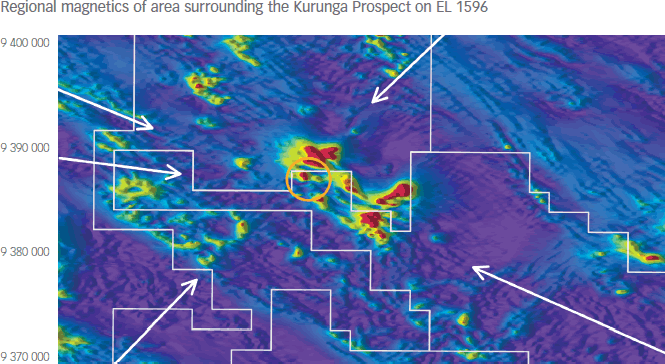
This image presentation (analytic signal) shifts the magnetic anomalies above the bodies producing them. The arrows highlight major structural features all of which intersect at Kurunga. The magnetic skarn mineralisation at Kurunga (below) correlates directly with the anomaly circled yellow (above)
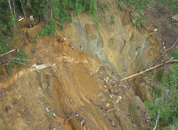
Artisanal workings at Kurunga where locals have exposed approximately 300m of strike of auriferous gossan. The gossan represents the surface expression of copper-gold skarn mineralisation.
Amanab Project (Harmony 100%)
The Amanab project – exploration licence application ELA1708 – was lodged on 6 January 2009 in the name of Harmony Gold (PNG) Exploration Limited, a wholly-owned subsidiary of Harmony Gold Mining Company.
The tenement is located approximately 160 kilometres north of the OK Tedi copper-gold mine in Sandaun Province and was pegged to target the bedrock source of the alluvial goldfield centred on the Yup River. Major PNG deposits at Porgera, Bougainville, and Morobe (includes Hidden Valley, Wau, and Edie Creek) all had similar alluvial gold occurrences established prior to discovery.
The tenement was granted on 6 July 2009. A low-level grassroots exploration programme will be undertaken in stages over the next 18 months.
South African brownfields exploration and retreatment projects
Mpumalanga exploration
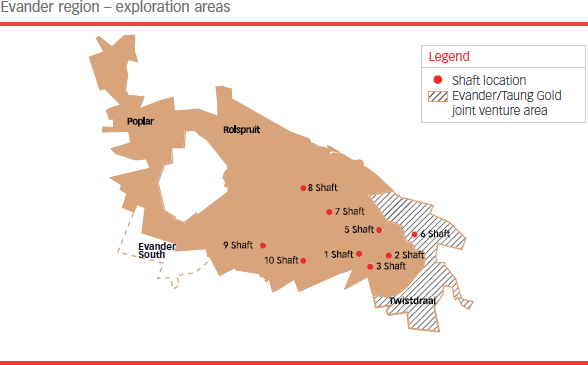
Evander South
Good progress was made at Evander South and the drilling programme there, two thirds of which had been done by year-end. The drilling programme is expected to be completed by December 2009 and the data to have been collated by the end of the third quarter of 2010. To date, five drill rigs have been used to drill 15 789 metres. In all, 24 000 metres of drilling from 43 holes is planned. Once this drilling programme has been concluded, and the geological resource revised, the existing pre-feasibility study will be updated.
It is anticipated that the drilling programme being undertaken here will lead ultimately to the establishment of a new, shallow, stand-alone mine, to be accessed initially via a decline shaft to a depth of approximately 500 metres and subsequently by a vertical shaft from surface to a depth of 1 060 metres below surface. Current estimates are that such a mine would have a recovered grade of approximately 4.5g/t with annual production of 1.2Mt over a 17-year life of mine which equates to 15 000 ounces/month and 180 000 ounces annually at peak production.
A decision on this project is expected in around two to three years time, and should the go-ahead be given, will take another three years from the start of decline development to first gold production. Initial estimates of capital expenditure are around R3 billion.
Poplar
Once the drilling programme at Evander South has been completed, a drilling programme will begin at Poplar, which is located 6 kilometres to the north of Evander South. Poplar also has the potential to be a stand-alone mine, with a mining depth of between 600 metres and 1 300 metres below surface and therefore also potentially accessible from surface. The envisaged drilling programme will be a continuation of the programme that began here in 2007 and stopped early in the 2008 financial year. Results from the drilling programme will allow the resource model to be updated and will almost certainly require a review of the feasibility study that was completed in 2003. The pre-feasibility study raised certain questions concerning the orebody, resulting in the planned drilling programme and, as at Evander South, once drilling has been completed, the study will be revised and updated.
Evander 6 shaft and Twistdraai
This orebody lies at the south-eastern end of the Evander gold field, adjacent to the current Evander 2 shaft orebody. Harmony entered into a joint venture agreement with Taung Gold Holdings (Pty) Ltd early in 2008 enabling Taung to earn into the projects to develop both these orebodies by fully funding and completing a bankable feasibility study. In terms of this agreement, Taung could earn-in an economic interest of up to 52%. To date, Taung has completed a competent person’s report and is in the process of completing a scoping study incorporating a detailed mining plan and schedule. Permission is also currently being obtained to drill a number of surface exploration holes of up to 2 kilometres deep.
Free State exploration
Joel North exploration
The surface exploration drilling programme, which started in May 2009, involves the drilling of six holes to a depth of 1 350 metres over a 12-month period and is aimed at upgrading the resource below the 129 level. A successful programme will require the existing shaft infrastructure to be extended below the current bottom working level and will prolong the life of mine for between five and six years.
Tshepong – B Reef Project
A four-year, R56 million exploration development programme to investigate the B Reef orebody and prove up this resource in the Leeuwbosch area north-east of Tshepong has begun. Small-scale mining of the B Reef on the west side of Tshepong indicated viable payshoots. This project will include 5.5 kilometres of underground development over two levels to a depth of 1 700 metres. In FY09, the first year of this project, initial surface drilling yielded positive results that were confirmed by preliminary underground drilling results which exceeded expectations.
St Helena – 10 Shaft
A feasibility study investigating the re-opening of this shaft is being completed. The shaft last operated in 2001, when it was owned by Gold Fields Limited, and has been under care and maintenance since its acquisition by Harmony in October 2002. It is likely that, should this shaft be re-opened, production from here will be used to replace tonnage from Harmony’s more marginal operations as they close at the end of their economic lives.
Retreatment projects
With the success of Project Phoenix (see the Review of Operations), Harmony has undertaken to extend the retreatment side of its business to include both more gold retreatment facilities and the retreatment of tailings for the extraction of uranium.
Project Saints
Project Saints will be located in the Free State province, and will be similar to the Phoenix retreatment project. Project Saints involves demothballing and upgrading the St Helena gold plant to enable the retreatment of 1 million tonnes of tailings per month. The focus of this project will be the eight tailings dams located in the Virginia and Welkom area which together make up about a third of the total resource available for retreatment.
The feasibility study for this project, which included drilling of the dams to determine the grade of gold contained, was completed and outstanding environmental issues are currently being addressed with final sign-off on these being imminent. Various funding models are being investigated and development is due to begin in FY10. The first phase of the project has an estimated capital expenditure budget of R622 million (the R345 million capital budget for the second and last phase of this project will only be spent in year 8 and will be funded by the project itself). Project Saints is expected to yield a monthly average of 6 000 ounces of gold over a projected life of 20 years. Production should begin 15 months from the start of construction.
This project has furthermore the added advantage of certain environmental benefits. Following the reprocessing of the material from the eight old tailings dams, the resultant waste material will be disposed of in two larger new tailings dams, built using up-to-date, improved technology that incorporates stricter design and construction specifications and is more environmentally friendly. As material from these old dams is re-treated, the resultant tailings will be deposited onto the new larger tailings dams, the first of which will be full after eight years (hence the need for further capital in year 8) and the second of which will have enough capacity to see the project through to completion. This project is expected to create approximately 200 permanent jobs in the Free State.
Project Libra
Similar to that of Project Saints is Project Libra which involves the treatment of old tailings dam material for gold in the Evander area. It is planned that this project will treat one million tonnes of tailings material per month, however, a plant would have to be constructed as there is no suitable mothballed plant available for refurbishment. A pre-feasibility study has been successfully completed and this project will be taken to the feasibility stage once the design work for Project Saints has been completed.
TPM Project
Ore from Harmony’s Free State mines contains uranium as a by-product of gold processing and the TPM Project envisages treating current arisings from the Tshepong, Phakisa, Masimong mines primarily for uranium. The initial concept is to reroute the milled ore from these mines, which is treated at the Harmony 1 gold plant, to a uranium plant initially, from where once the uranium has been extracted, the arisings will be returned to the gold plant for gold extraction. This has the added advantage of improving subsequent gold recovery rates.
A pre-feasibility study into the establishment of a uranium plant is currently under way and scheduled for completion by November 2009 following which a nine-month full feasibility study is planned. The project is expected to involve the construction of a R1.4 billion uranium treatment plant with deposition sites and water usage being the same as those for treating gold.
The feasibility study will include plans to build a pilot plant, followed by the construction and testing of a larger demonstration plant. Thereafter, and upon final project approval, the actual plant is scheduled to take two years to build after which first production will begin.
In addition, studies to investigate the viability of extracting uranium from tailings facilities at Harmony’s Free State operations are under way. The most likely source of tailings for such a venture would be directly from the current gold tailings retreatment operation of Project Phoenix (Saaiplaas plant) and the envisaged Project Saints (St Helena).